


GPS Camera - GeoTag Map
Description of GPS Camera - GeoTag Map
GeoTag Map is a GPS Camera application designed for users seeking to enhance their photography with precise location data. This app allows users to easily add geotags, timestamps, and other relevant information to their images, making it particularly useful for travelers, outdoor enthusiasts, and professionals needing accurate documentation of their surroundings. Available for the Android platform, individuals can download GeoTag Map to transform their mobile devices into powerful tools for capturing and organizing geotagged images.
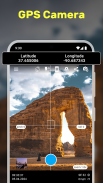
The app's primary functionality revolves around its ability to integrate GPS information directly into the photos taken. When users capture an image, the app automatically embeds relevant GPS coordinates, altitude, and accuracy details into the photo's EXIF metadata. This feature ensures that every image carries essential geographical context, which can be beneficial for various applications, including travel documentation and site-specific data collection.
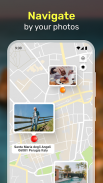
GeoTag Map also provides a user-friendly interface that allows for effortless navigation through photo collections. Users can access their geotagged photos in different viewing modes, including Image Mode and Gallery Mode. In Image Mode, individuals can view images along with their geolocation data displayed on a map. This functionality helps users visualize where their photos were taken, adding depth to their travel experiences and allowing for easy reference in the future.
In Gallery Mode, images can be organized based on various criteria such as creation time, name, or distance from a specific point. This organizational feature enables users to maintain a structured collection of geotagged photos, making it simpler to retrieve specific images when needed. The flexibility in organization supports both casual users and professionals who require efficient cataloging of images for work-related purposes.
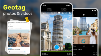
GeoTag Map offers additional customization options for users interested in personalizing their photos. The app allows users to add geostamps to their images, which can include specific dates, times, and locations. This customization enhances the storytelling aspect of photography by providing context about when and where each photo was taken. Users can include text or voice notes alongside their images, adding an extra layer of detail that can be useful for later reference or sharing with others.
Another salient feature of GeoTag Map is its visualization capabilities through the map GPS camera. Users can view their geotagged photos on various map styles, such as standard or satellite views. This functionality assists users in understanding the geographic distribution of their photos, revealing patterns and stories hidden within their travels. The ability to visualize locations in this manner makes the app particularly appealing to those who enjoy exploring and documenting their journeys in a meaningful way.
For agriculture and urban planning professionals, GeoTag Map serves as a powerful tool for documenting field conditions and reporting urban issues. Users can capture and geotag photos of specific sites, such as crop health or infrastructure concerns, ensuring accurate documentation for analysis and reporting purposes. The app's robust features, including the ability to collect and analyze vital geodata, make it suitable for a wide range of professional applications.
Sharing and exporting capabilities are also integral to the GeoTag Map experience. Users can easily share their geotagged photos with friends, family, or colleagues, facilitating collaboration and communication about shared experiences. Additionally, the app allows users to export images with geostamps in various formats, including KML, CSV, and XLS files. This flexibility in exporting data ensures that users can utilize their geotagged photos in different contexts, whether for personal use or professional presentations.
As users engage with GeoTag Map, they will find that the app caters to both personal and professional needs. Whether one is documenting a hiking trip, capturing urban landscapes, or collecting data for agricultural assessments, the app adapts to various scenarios, providing essential tools for effective geotagging. The straightforward interface, combined with powerful features, makes it accessible for all users interested in enhancing their photography with location data.
GeoTag Map stands out as a versatile application that effectively combines photography with geographic information. Its capabilities for adding geotags, customizing geostamps, and visualizing photo locations create a comprehensive tool for users interested in documenting their experiences accurately. Those who download GeoTag Map will discover an efficient way to capture and share their memories while ensuring that every image tells a complete story with precise GPS data.
By integrating innovative features and user-friendly design, GeoTag Map is positioned as a valuable asset for anyone looking to enrich their photography through geotagging. With its diverse applications across various fields, the app is a reliable choice for users seeking to document their travels or professional activities effectively.
For more information, visit the app's official page.
GPS Camera - GeoTag Map - APK Information
APK Version: 2.1.2Package: travel.minskguide.geotagLatest Version of GPS Camera - GeoTag Map
Other versions


Apps in the same category


You may also like...


